

Does The FCC Know Where Your Station Is? Do You?
[August 2022] When an FCC Field Agent or an Alternate Broadcast Inspector comes calling to inspect a station, they start by bringing up the coordinates from the FCC database. Then they check their GPS receiver. Sometimes, it is funny what they find.
You likely have heard some of those stories about how a radio inspector showed up at a station only to find that there was nothing there.
Sometimes you can figure out what happened. The station moved but the FCC data was not updated. Or there was a human typo error when a form was filled out. Or someone used an 1890 topo map. Or the FCC database got corrupted.
Experienced engineers have seen all of these, and more. Some of the consulting engineers even have “favorite” examples. What would you say about an STL shot that apparently ran some 200 miles and, even better, terminated somewhere out in the Atlantic Ocean? That is, aside from saying you are not going to inspect that receive site. Yes, that one was a typo.
But with some indication of increased attention by the FCC’s field personnel to this matter, it might well be a good idea to pull out all of your licenses and check the site data.
When Good Data Goes Bad
Of course, even without typos, there are a lot of opportunities for errors to creep into applications and other forms.
For example, the government itself makes filing a crazy quilt of differing standards:
- The FCC Media Bureau wants you to use NAD27 coordinates for your tower location, to the nearest second – height measurements are to the nearest tenth of a meter.
- A sister bureau, the FCC Wireless Telecommunications Bureau, wants you to use NAD83 on your ASR (Antenna Structure Registration) form – along with height measurements to the nearest tenth of a meter.
- The FAA, however, wants you to use NAD83 coordinates on the Form 7460 – with height measurements in feet.
- If you have to file a form with the FEMA, you are asked for coordinates in Degrees and Minutes in decimal form, as opposed to the FCC and FAA requirement of Degrees, Minutes, and Seconds (to 0.1 Second).
Just putting the same numbers on each form will leave you with a lot of coordinate and height errors. Be sure of your data set; e.g. Google is NAD83. Conversion utilities are available: NAD27 <-> NAD83, or if you go to fccinfo.com and select your station, both NAD27 and NAD83 coordinates are shown. By clicking “map it” after selecting a station, you can see a chart of converted coordinates, DMS and D.MS.
True, some variations are minor, but they can be confusing. Worse yet, it is always the licensee’s responsibility as 73.1350(a) and 1.65(a) state that each applicant is responsible for the continuing accuracy and completeness of information.
In other words, it is the station’s responsibility to check communication from the FCC to make 2 sure all the data is still correct – and that it corresponds with all other licenses and applications.
Was it the licensee or the FCC that made the error last year where an antenna was found to be 11 miles from what was shown in the ASR? It does not matter to the FCC; it is the licensee’s responsibility to notify them of any errors within 30 days. (By the way, it is also the licensee’s responsibility to notify the FCC when a tower is actually built and placed into service.)
How Far is Too Far?
While there is no specific number in the Rules, general policy has been to expect accuracy within one geographic second. That is only about 100 feet or so, but well within the range of most current GPS receivers.
For that reason, the Commission issues Notices of Violation (NOV) and Liability (NAL) to the towers that are found significantly away from the licensed spot.
During inspection, this AM tower was located about 1000 feet from the coordinates in the FCC database – and apparently not in compliance with the tower registration Rules.
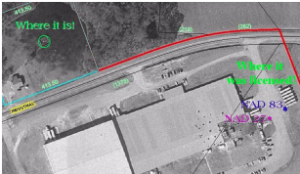
The NAD83 mark is where the tower should have been by FCC Data. The NAD27 mark is where it would plot if the data was not converted to NAD83. The “Where it is!” just is not where the FCC thinks it should have been.
Cleaning the Stables
Some ten years ago, the FCC noticed that there were a lot of errors in their database, and requested that all stations check, making corrections relatively easy during a time window.
As you may expect, the FCC continues to find examples where licenses still do not match the actual site where the antennas are found. Some of the Bureaus are using computers to compare the various forms and search for obvious errors.
Still, a lot of errors in the FCC database, errors that continue to cause consternation. Some are slight, some more trouble-some. And it will come as no surprise that the Enforcement Bureau is getting more aggressive in dealing with the errors the FCC finds. In other words, more fines can be expected.
The best way to protect your station is to find any errors – even on stations that go back many decades – yourself before the FCC does.
When You Discover an Error in the Field
Although there is no specific number in the Rules, general FCC policy has been to expect accuracy within one geographic second. That is approximately about 100 feet or so, but well within the range of most current GPS receivers.
On the other hand some stations like the one above have discovered they are perhaps 11 to 12 Seconds away from where they should have been located. That is not good. A few decide they would rather not say anything, hoping the FCC will not find out and fine them. That is worse.
The bad news is that situations like the one above really require the efforts of a DC attorney to avoid the Enforcement Bureau from simply slapping on a stiff fine as corrections are made months or years late.
On the other hand, the FCC notes that under 73.1690(c)(11) licensees are permitted to correct up to 3 Seconds of latitude or longitude without prior Commission approval. For those stations with separation worries, a letter from the FCC indicated that rounding to the nearest kilometer – and even tiny encroachments (0.09 km) are not going to bring down wrath on licensees trying to correct data.
A quick conversation or email with your DC counsel may well save you a lot of grief later.
Watch for These, Too
Another category of bad data concerns stations whose licenses have expired due to anything from an application bounced for lack of accompanying fee to an error during a sale/acquisition to, yes, plain old clerical errors.
Before the FCC cites you for operating without a license, check that instrument of authorization on the wall.
At the same time, there may well be licenses you used to have and no longer use – for example, RPU licenses – that routinely get renewed term after term, even if the equipment was retired years ago. One cluster had an RPU license that had come from an acquired station, although the RPU transmitter was taken out of service 20 years before.
Cancelling or otherwise terminating old Auxiliary Services (Part 73) licenses could save you a considerable amount of money for regulatory fees and/or fines for no longer being where the licenses says you should be.
Where to Look
Start with your license book at the Control Point, usually the Control Room. Check each one for consistency and errors. Remember, if you change one, you may need to change others as well.
With the FCC’s CDBS being deprecated, you will want to check the LMS to see current information on what your license should say. In recent years, the Commission has sent out different patterns of licenses or merely renewal notices. A quick check to see what is online and how it compares will prevent any hassles there.
It is also wise to check the FCC’s LMS for any licenses missed. Then you might want to check the WTB two-way business and the International satellite databases.
Knowing your facility number is also helpful. On these various databases, plug in your call letters, facility number, and/or company name. And make sure you enter your coordinates, set a radius, and see what pops up.
Why is all this so important? You might find another station using frequencies you thought were clear. Some STL interference has been identified and resolved this way, as well as competing RPU channel issues.
But sometimes, such a search comes too late.
Let us just point to an un-named station that lost its Part 73 channel because of incorrect data in the FCC database. Another station filed – and was granted – a license that now precludes the first station from operating. Although they were there first, by failing to protect their license by checking the database, they were deemed to have given up their rights to that channel.
If you do not want to do this yourself, hire your consulting engineer to go through the data he has on file and work with him to ensure accuracy. The only thing you have to lose is a lot of time dealing with forms, applications, lawyers and the FCC.
Would you like to know when more articles like this are published? It will take only 30 seconds to
click here and add your name to our secure one-time-a-week Newsletter list.
Your address is never given out to anyone.
Return to The BDR Menu